Ecology: Biology of Interactions. III-04. Classification of Biomes
A biome is a large type of biogeocenosis characterized by a similar nature of vegetation and occupying certain regions of the planet. Biomes are regulated by macroclimate and primarily by the amount of precipitation and temperature
III-4. Classification of biomes
What types of biogeocenoses exist? Everyone knows that a biogeocenosis in which producers are represented mainly by trees is called a forest. Biogeocenoses located in arid climates, where grasses dominate, are called steppe in Eurasia, prairie in North America, pampa in South America, and veld in South Africa. To understand the diversity of biogeocenoses, some classification is needed. There are quite a few such classifications, and the one used here is probably the most commonly used in the international scientific community. The unit of this classification is the biome.
A biome is a large type of biogeocenosis characterized by a similar nature of vegetation and occupying certain regions of the planet. Biomes are regulated by macroclimate and primarily by the amount of precipitation and temperature (Fig. III-4.1).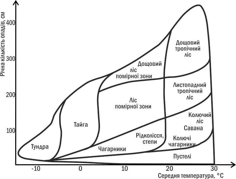
Fig. III-4.1. Distribution of some terrestrial biomes depending on precipitation and temperature
Biomes have a certain integrity. For example, between the zones of deciduous forests and steppes lies the forest-steppe zone, where the biomes of forest and steppe "meet". Under the current climate, both types of biogeocenoses can be stable on the territory of the forest-steppe. The forest requires more water than the steppe, but forest soil retains it more effectively than steppe soil. Where a forest already exists, enough moisture is retained in the soil for the forest to exist. Where a steppe is located, there is insufficient water for forest development. When the humidity or temperature of the climate changes, a gradual movement of the boundaries of forest and steppe occurs. A dry forest is replaced by steppe, a moistened steppe becomes overgrown with forest. However, a wide strip remains where two types of ecosystems alternate in a mosaic pattern. Waterside areas, ravines, and lowlands become covered with forest, while areas with sandy soil and well-warmed slopes become steppe. The characteristic type of vegetation depends on the soil and climate and influences them, and also determines practically the entire composition of the community that develops in a particular location.
How to show the relationships of different types of communities to each other? There are two main methods — ordination (i.e., arrangement in some space in a certain order) and classification (i.e., distribution into groups separated from each other — classes or taxa). Ordination emphasizes the continuity of changes in properties, classification — the discreteness of gaps. An example of community ordination is shown in Fig. III-4.1. An example of a multilevel hierarchical classification of biomes is given below.
The main biomes on Earth are as follows.
Terrestrial biomes
Tundra. A biome of cold humid climate, characterized by negative mean annual temperatures, precipitation of about 200–300 mm per year, and most often the presence of a permafrost layer. Arctic tundra, located at high latitudes, and alpine tundra, located in high mountains, are distinguished. Vegetation consists of low-growing perennials: lichens, mosses, grasses, and shrubs.
Taiga. A forest biome of cold climate with a long snowy winter and precipitation exceeding evaporation. The main forest species are conifers; tree species diversity is low (1–2 dominant species).
Deciduous forest. A forest of the temperate zone. It develops in regions with moderately warm summers and relatively mild winters with frosts. Characteristic features are even distribution of precipitation, absence of droughts, and precipitation exceeding evaporation. In autumn, as the length of daylight decreases, leaf fall occurs. Deciduous forests are relatively species-rich and are characterized by a complex vertical structure (presence of several layers).
Steppe. An area of herbaceous vegetation in the semi-arid zone of a temperate climate. The most numerous grasses are graminoids and sedges, many of which form a dense sod. Potential evaporation exceeds the amount of precipitation. Characteristic are soils rich in organic matter — steppe chernozems. Synonyms — prairie, pampa, veld.
Savanna. Tropical grass-tree communities that develop in areas with a stable alternation of dry and wet seasons. Individual trees or clumps of shrubs are scattered among open grassy areas.
Desert. A fairly diverse group of biomes located in areas with an extremely arid climate or, in the case of arctic or alpine desert, extremely low temperatures. Sand, rocky, clay, salt flat, ice, and other deserts are known. Characteristic (with the exception of ice deserts, which develop in very cold conditions) is either mean annual precipitation of less than 25 mm, or conditions that ensure very rapid evaporation of moisture.
Chaparral. Hard-leaved shrubby thickets in a Mediterranean climate with mild rainy winters and dry summers. Characterized by significant accumulation of dry wood, which leads to periodic fires.
Seasonal tropical forest. Common in areas with a hot climate and abundant precipitation distributed unevenly throughout the year, with a dry season. Extraordinarily species-rich.
Evergreen rainforest. The richest biome, located in regions with abundant precipitation (> 2000) and nearly constant temperature (about 26°C). These forests contain 4/5 of all plant species on Earth; woody vegetation predominates.
Freshwater biomes
Lentic (standing) waters. Puddles, oxbows, natural and artificial ponds, lakes, and reservoirs. Living conditions are determined primarily by depth (and light availability) and the amount of nutrients. Exchange of nutrients and gases between the surface and depth is often impeded.
Lotic (flowing) waters. Streams, brooks, and rivers. Conditions depend greatly on the speed of the current. They are capable of transporting significant volumes of water and other inorganic and organic substances, and are closely linked to the surrounding terrestrial systems.
Bogs. Water bodies with a large amount of organic matter, the decomposition of which is slowed due to oxygen deficiency in the water; mainly characteristic of temperate and moderately cold climates.
Marine biomes
Pelagial. The open ocean and sea depths far from shores. Producers (primarily phytoplankton) are concentrated in a relatively thin near-surface layer of water where light penetrates. Characteristic is the continuous sinking of nutrients from the surface to the depths.
Continental shelf. The coastal zone of seas and oceans, reaching approximately 200 m depth. Species-rich and diverse marine communities. The most diverse aquatic ecosystems, characteristic of coral reefs, also belong to the continental shelf. "Hotspots" of biodiversity are also characteristic of great depths — for example, of sites where volcanic gases emerge into seawater ("black smokers", see item III-5, and other phenomena).
Upwelling zones. Relatively small areas of the ocean where deep waters enriched with nutrients rise to the surface. They have an exceptional influence on the productivity of the entire ocean.
Estuaries. Zones of mixing of river and sea waters, formed in seas opposite the mouths of large rivers. Characterized by significant amounts of organic matter carried into the sea by rivers, and constant fluctuations in salinity.